

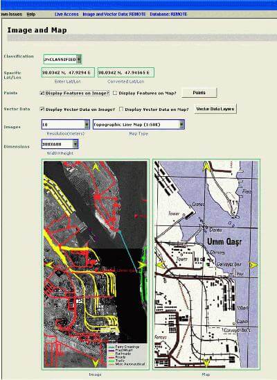
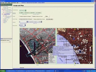
Information, Please: Flexible map interface highlights desired information on parallel displays of satellite images and maps. Pull-down menus select desired features for emphasis, or to change scale.
Meet the military (and commercial traveler’s) map of the 21st century.
Decades worth of detailed, accumulated geographical information is now available to front-line troops in a concentrated, portable, easy-to-use laptop package created by the University of Southern California.
HeraclesMaps can instantly solve life-and-death tactical questions like, “Help us find a route from point A to B where we cannot be observed (or shot at) by someone at point C.”It can instantly dissect the geography of a city, showing users the electrical power grid, all rail, roads, pathways, and and other man-made features, plus much more both in map and photographic form.
After intensive trials over a five-year development period, it is now in use by selected units of the U.S. armed forces in training.
Computer scientist Craig Knoblock of the USC Viterbi School of Engineering Information Sciences Institute led a team that developed the system working with specialist veteran consultants.
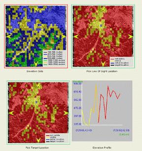
Safe Passage: An interface can show users what areas can be seen from what other areas, allowing them to chart a safely hidden route.
The main challenge was, the scientist earlier wrote, that information “obtained from various data sources may have different projections, different accuracy levels, and different inconsistencies. The applications that integrate information from various geospatial data sources must be able to overcome these inconsistencies accurately, in real-time and for large regions.”
Knoblock says HeraclesMaps digests satellite imagery, mapping data, and allows users to access the full range of the date quickly and intuitively through an interface that anticipates questions.
“This material had been distributed on multiple CDs that, essentially only specialists could use,” said Knoblock. “HeraclesMaps lets strategic and tactical planners ask their own questions and get their own answers, on the spot, instantly, using an easily portable laptop computer”
Many civilian applications are possible, Knoblock says, including an extremely powerful travel planner.
The Heracles project, the parent of Heracles maps, uses a variety of powerful tools including artificial intelligence agents to extract and dynamically reconfigure information from diverse sources.
Other Heracles applications can potentially add data from on-line or other sources, so one might access additional databases to highlight (for example) the cheapest fuel available, or all-night restaurants serving a specific cuisine.
For Knoblock’s work on such agent-driven information collection and organization systems, he was this year honored by being elected a fellow of the American Association for Artificial Intelligence, one of only six researchers worldwide so honored in 2004.
(Below) Back in the U.S.A. For civilian tourists or business travelers, map and image annotations reveal detailed information about specific points when a cursor passes over them.
Published on May 28th, 2004
Last updated on August 9th, 2021