Photo Credit: duncan1890/iStock
A bright future is on the horizon for the United States’ assessment of critical minerals, thanks in part due to the work of a team of students and professors from USC Viterbi Information Sciences Institute (ISI) and the University of Minnesota (UMN).
The USC-UMN team came in first out of 56 teams in the Map Feature Extraction Challenge as part of the Defense Advanced Research Project Agency (DARPA) AI for Critical Mineral Assessment Competition on Nov. 17.
The competition is an initiative put on by DARPA in partnership with the U.S. Geological Survey (USGS) in hopes of improving the process of assessing the nation’s critical minerals.
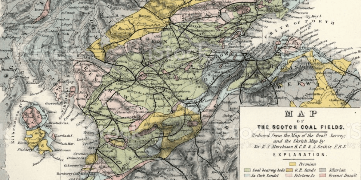
Critical minerals are used to manufacture products that are integral to national security. Currently, their assessment is slow and labor intensive–it involves sorting through historical geological maps and their legends by hand to locate the coordinates of critical minerals. The assessment of one critical mineral typically takes two years. Automating the process will make the U.S. government’s supply chain more efficient and decrease reliance on foreign company imports of these resources.
The Map Feature Extraction Challenge required the team to identify and label map features–lines, polygons, and points– that appear in the legend of historical maps. To the human eye, these features often blend in with its surrounding contours and can be difficult to decipher with precision.
The competition timeline was split into three distinct phases: training, validation, and testing. The training phase began on Sept. 15, 2022, when DARPA and USGS released datasets for the team to train its model on. Sept. 28 to Nov. 9 served as a practice round. The team submitted their extracted results from the training datasets during this period to make sure they were on the right track.The testing data was then released on Nov. 16., and it was a quick turnaround–the team only had 30 hours to generate their results and submit them on Nov. 17.
The three graduate students that made up the team include USC Viterbi computer science PhD students Weiwei Duan and Fandel Lin as well as UMN computer science PhD student Zekun Li.
Lin said one of the biggest challenges was dealing with color shift issues in the geological maps that are decades or even centuries old in some cases. Much of USGS’s content is not digitized, so the team often worked with scanned images of paper maps.
“Sometimes these maps deteriorate with age and must go through post processing, which means we have to relabel or link the mismatch of colors from the legend to the map so that we can correctly extract it.”
In some cases, points, lines, and polygons blend in with surrounding features, such as if their contours are drawn in the same or similar colors.
“Ultimately we want to automatically detect and fix these color shift issues in the map–this is one of the important findings of the project that needs some future work,” Lin added.
ISI Research Director Craig Knoblock and Yao Yi Chiang, Associate Professor in the Department of Computer Science & Engineering at UMN, served as the team’s two advisors.
Knoblock highlighted that Professor Yao-Yi Chiang’s PhD research, which he completed at ISI, covered the extraction of road vectors and text layers from maps. Additionally, during the years Chiang worked at USC in the Spatial Sciences Institute, he and Knoblock collaborated and expanded on this research. The many years of experience working on “very similar problems,” Knoblock said, provided a “huge advantage for the USC-UMN team.”
Knoblock also echoed the belief that the work the team accomplished in the competition will streamline feature extraction and effectively lighten the manual burden that currently plagues the process.
“Much of the data for mineral assessment is currently locked up in maps and it requires a tremendous amount of effort to manually extract this data from the thousands of USGS maps that contain this information,” Knoblock said. “The tools we are building can greatly accelerate this task and reduce human effort.”
Published on February 17th, 2023
Last updated on May 16th, 2024